


A round of storms roll through the Lakes Region with a unique pattern.
Two lines of storms formed that moved from southwest to northeast generating large hail, damaging winds, and some tornados. One line formed in northeast Oklahoma late Friday afternoon and strengthen to severe levels in the Bentonville-Fayetteville area of northwest Arkansas, and hit part of northern Carroll County before coming into Missouri, striking much of Barry and Stone Counties, a smaller section of Taney County northwest of Branson, then hitting most of Christian County moving northeast.
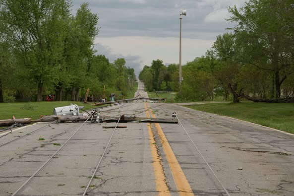
The second line began forming early evening in areas around Harrison then merged with another line moving into south central Missouri where it caused some major damage around the West Plains area.
In between, except for the strong winds that impacted the whole region, very little rain and no storm development. That area included much of Branson and Hollister which saw the strongest storms stay just to the northwest. Despite no direct storm damage during the day Friday there reports of trees down due to strong winds, including one posted on Facebook by the Branson Tri-Lakes News on East 76 near Lakeshore Drive.
Storm reports to the National Weather Service from areas that did get hit include quarter size hail in areas of Chestnutridge and Saddlebrooke near the Taney/Christian County Line, That was part of a line of hail reported from around Golden and Shell Knob in Barry County, through the Reeds Spring area of Stone County and into Christian County, where the largest hail reported was baseball size around Highlandville. Several reports of trees down in those areas as well, some from strong winds prior to the storms and some during the storms.
In Arkansas, the National Weather Service reports included over one inch size hail around Summit in Marion County as well near Gum Springs in Newton County while strong winds during the storm knocked down a tree on Highway 65 south of Leslie in Searcy County.
The front that caused the storms and strong winds will cool temperatures down into the 50s and 60s for the weekend with overnight lows in the 30s. A quick warm-up will have temperatures back in the 70s by Monday.


 A Brief Rain Break as Storm Recovery Continues
 Another Scam: BPD Warns of Scam Disguised as Help From Other Agency
 The Hat-titude Ball Coming Up
 It’s a Three-Peat for Silver Dollar City


